Local Angle: How Coastal Exposure Affects Wind Forecasts in Cornwall
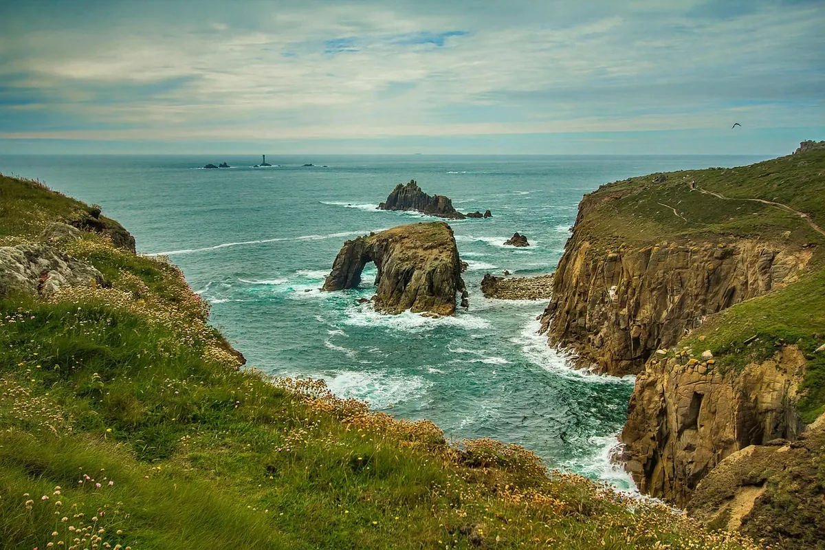
Stand on the clifftop at Trevose Head on an afternoon when Truro feels almost still, and you meet the real forecast: a hard, steady push of air, grass flattened, gulls hanging, hoods up. Cornwall does not have one wind forecast. It has dozens, and the coast usually wins.
The county is narrow, ringed by sea and ridged with high ground down the middle. Air arrives from the Atlantic with a long, open run of water behind it, crosses a few miles of land, then meets the sea again. Every one of those transitions changes what an anemometer records — and what you actually feel.
Why the sea gives wind an easier ride
Over water there is very little to slow moving air. Over land, hedges, trees, farm buildings and rolling fields create friction, which drags at the lowest layer of the wind and shaves off speed. A sheltered town a few miles inland can therefore sit in noticeably calmer air than an exposed beach under the same forecast.
Fetch is the other half of the story. Wind arriving from the west or south-west has a very long, unobstructed run before it reaches Cornwall, and long fetch means well-mixed, persistent, organised wind rather than the fitful stuff you get inland. The sea also flattens out the daily rhythm. Inland, wind often drops away after dusk as the ground cools; on an exposed coast it can carry on regardless, which is why camping near the cliffs feels so different from camping in a wooded valley five miles away.
Headlands, cliffs and funnelling
Cornwall's shape does more than just expose you to the wind. It speeds it up.
Headland acceleration
Air that meets a headland has to go somewhere, and much of it goes around the side. Squeezing a broad flow past a narrow promontory increases its speed, which is why Gwennap Head, Cape Cornwall, the Rumps and Pendeen can feel a notch or two windier on the Beaufort scale than the nearest sheltered cove. The effect is strongest on the windward shoulder of the headland and eases as you move downwind.
Valleys as funnels
A valley mouth opening onto the coast acts like a nozzle. In a north-westerly, air that has been channelled down towards the sea can arrive at the beach stronger and more gusty than anything a mile upstream suggests. Some coves sit perfectly in the lee of their own valley walls for one direction and catch everything for another.
Cliff-top turbulence
Cliffs push air upwards as it hits them, so the flow at the top of a path is rarely smooth. You get lulls, then a sharp shove as you step out past the last wall of gorse. Winds over cliffs and around rock buttresses feel gustier than the average speed implies, and that matters for tents, boards and anyone carrying something wide and flat.
Why your app shows a gentler number
Forecast models work on a grid, and each grid point stands in for a patch of land or sea. Hills and cliffs are smoothed out; a headland is often represented as a lower, rounder version of itself. Official observing stations are also sited for aviation or general weather reporting, which usually means flatter, more accessible ground — an airfield or a set-back coastal site — rather than a 90-metre granite promontory.
None of this makes the forecast wrong. It makes it a starting point. If your chosen spot is a headland, a cliff path or an exposed beach, expect the real wind to sit above the town's number, sometimes well above. If you are heading inland into a wooded valley or a sheltered harbour, expect less.
Which coast, and which direction
Direction matters as much as speed. In a south-westerly, the north coast from St Ives Bay up through Newquay, Padstow and Bude takes the full Atlantic hit, while parts of the south coast sit more comfortably in shelter. In a north-westerly, the focus shifts: north-facing beaches cop it, and some south-coast spots become the pleasant option. In a south-easterly, the usual order is reversed and the north coast can be surprisingly calm.
Then there are the local quirks. Peninsulas like the Lizard and Land's End can produce marked shifts in direction over just a few miles, and headlands deflect the flow around them rather than through. On warm, calm summer days, a sea breeze can build along the coast during the afternoon, adding a fresh onshore wind when the wider forecast says barely a breath. Morning flat, afternoon breezy — that pattern is often a sea breeze, not a broken forecast.
What to check before you go
- Use a coastal point, not the nearest town. If you are walking the coast path near Zennor, a forecast for Penzance will understate what you meet on the cliffs.
- Compare two or three nearby locations. If they disagree, plan for the windier one and be pleasantly surprised if it is gentler.
- Read the direction, then ask if it is onshore. An onshore wind brings swell, spray and a windier beach; an offshore wind often means calmer sand but gusty, unpredictable air just above the cliff line.
- Look at gusts, not just average speed. Gusts decide whether a tent stays up, a paddleboard is manageable or a bike feels twitchy on an exposed lane.
- Check the inshore waters forecast if you are going on the water. The marine areas covering the Cornish coast — including Land's End to Hartland Point and Lizard Point to Land's End — add sea state and swell detail that land forecasts leave out.
- Check warnings, radar and the tide. Squally showers and warnings tell you more about the next few hours than a daily average ever will.
- Pack for the windier version of the day. A windproof layer weighs almost nothing and is the difference between a good walk and a miserable one.
Gusts, squalls and showers
Cornwall's wind is rarely steady for long. Showers streaming in off the Atlantic drag faster air down from above, producing short bursts that arrive with little warning and then pass. A cold front can swing the wind round sharply and strengthen it within minutes. On bright, unstable days, heavy showers inland can push their own outflow towards the coast, so a beach can go from calm to lively as a cloud passes overhead.
Practical rule of thumb: the gustier and showier the sky, the wider the gap between the average wind speed and the strongest gusts. That gap is what catches people out on exposed ground, on slipways and in small boats.
Matching the forecast to where you'll actually stand
Pick the point that best represents your day — a headland if you are walking the cliffs, a harbour if you are launching a kayak, a valley if you are camping inland — and then add a sensible margin for exposure. Hold your plans loosely enough to move a beach, shift a walk or change the timing of a paddle. If you are heading out on the water, take local advice on conditions at your launch and exit points; they can differ from anything a screen shows you.
Check official warnings before you set off, tell someone where you are going, and turn back if the wind is doing more than you planned for. Cornwall rewards people who read the coast as carefully as they read the forecast — and it is far more enjoyable when the wind is something you saw coming.
Photo: diego_torres / Pixabay

You Might Also Like
A practical guide to building a personal severe weather watch routine: checking forecasts, setting useful alerts, and writing a simple trigger plan before the storm arrives.
UK wind records are messier than they look. This explainer covers what the data can and cannot tell us about wind trends, and why weather is not climate.